INSPIRATION

To help contain Corona, we have really contained our love for travel in the last 5 months! Confident in my social distancing skills, I was ready for an adventure and to see a new part of the country for my birthday leave and settled on Taita Taveta. I had seven days, my motorbike (a Spirit built on the Honda 125cc) and a limited budget. With around 5,000 km riding experience, I count myself an advanced beginner and had never done much more than 220km in a day. Therefore I did quite a bit of research and talked to a few peeps to plan and anticipate my route.
The plan ended up being: Nairobi to Taveta via Oloitoktok. After a few days around Taveta, head over to Taita Hills. Back home via Voi and Mombasa Road with a detour via Makueni’s Wote.
Main questions in my head were: How will I handle the trucks and oncoming traffic on Mombasa Highway? Can I hack and enjoy dozens of kilometres on rural rough roads?
In summary: It all went well and the area is breathtaking. Y’all should go there and maybe this blog post will be helpful if you’re thinking of it.
Day 1: Nairobi to Taveta town
This is 320km long and comes in 3 stages:
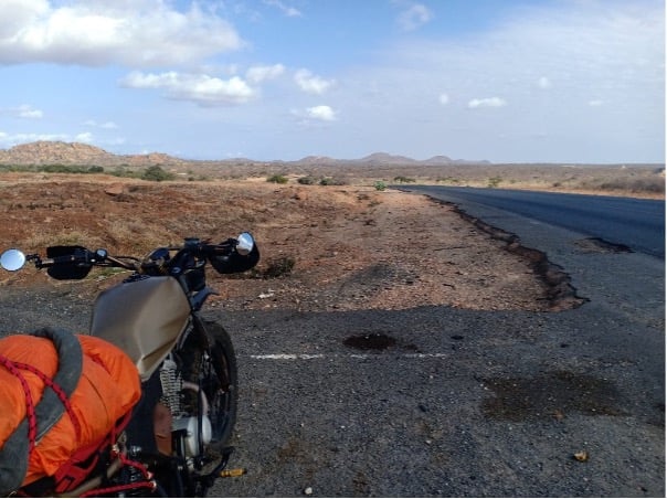
First stage is 130km along Mombasa road
As you’d expect, the challenge was the oncoming traffic, where mats, cars and lorries come at you in your lane. But that piece has a good run-off area which you need to be ready to use. After the Machakos junction it gets more scenic and less busy. I’d recommend leaving Nairobi at 6-7am so that you get to Emali by 9/10 and are off the highway before it gets too busy. I didn’t follow my own advice and left Nairobi at 10 and got to Emali at 12:45 after a few photo stops.
After passing Emali town (get fuel and water) you ride over a bridge that’s worth stopping on to soak in the views of Emali and the railway (old and new). During the SGR construction a higher new bridge was built here, but the old bridge is “kinda” still there, with 15 metres missing in the tarmac, looks like an excellent spot for a sunset date if you ask me…
Stage 2 is through Maasai land up to Oloitoktok
This is 100km of excellent road. Very enjoyable. You’d easily make it in 1hr 15 but I kept stopping for photos.
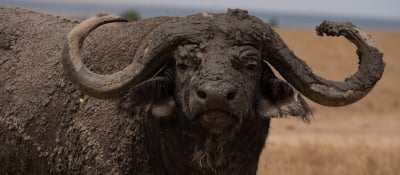
Especially once you pass the cement factory it’s pictureque. Cattle herded by kids, gazelles grazing, a watering hole directly at the road (dry now). Lots of beautiful acacia trees and hills.
A word on fuel: The last Shell before Voi on this entire route is 10km to Oloitoktok. I ignored it, as I was in full swing, thinking that Oloitoktok must have a Petrol Station.
Now, Oloitoktok town itself is sadly totally underwhelming. I got harassed while fuelling by some kids on bodas chewing miraa. Maybe the lunch places were closed because it’s Sunday? What I hoped would be a nice lunch break ended up a 1min maps check at National Oil. I got biscuits just before the tarmac ends (Oil Lybia in Laset).
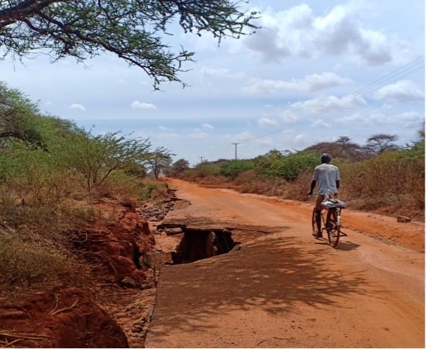
Stage 3 is the rough road stretch. 72km from Laset to Taveta Town
The bodas in Laset said that it’s not too bad. Well, I am new to this… I took 1hr for the first 12km. Passed a couple of stretches with 20cm deep sand. Stones, potholes, you go at 15km/h. At one spot I slipped off the sandy road into a gully. The boda guy who helped me get the bike out said that Taveta is 70km. “So 2hrs?”, I ask. “You’ll be there in one”, he answered. Lol!
In summary, I took 3.5 hours for the 72km and learned a lot about riding in sand and how to relax your shoulders with all the sliding and how to cover miles on bumpy uncomfortable ground.
Day 2 – Too Lake Chala
Sometimes the white part is best to ride. Sometimes the black. Sometimes the sand. Sometimes the hard parts inbetween the sand… YO!
It’s not too scenic, but lots of trees to rest under if you had snacks. I didn’t stop to take any photos of the really bad patches. It’s safe generally speaking. But there were around 4 parts where floods had taken away the road, and they’re not very visible as there are many small hills. You might actually fall in a 3m deep hole I ended up following the local bodas, as they really know the route and that worked out well.
The last 20km were VERY pretty as the sun was already setting. I really started enjoying riding the waves on the sandy road with around with 35 km/h… I felt like a hero!
Didn’t stop too much, as I started to worry that I might get to Taveta after dark. Again, leaving Nairobi early would give some allowance for breaks or punctures (thorns!!).
Then you get to the small bridge near Lake Chala – the sign you’re nearly there.
You can’t see the lake as it’s a crater lake, but it’s very pretty that side. If you were earlier, you could go take a dip in the lake… Here is where I realized that I’m sandy up to my knees and the bike needs a serious wash. I started to feel like I’m on vacation.
The most lol part was the junction that on Google Maps is a junction between two roads next to the railway line. While planning my trip on Google Maps, I envisioned myself turning right here towards town. But things kwa ground…. It is literally a sandy patch with bushes in the middle of the road so I went on straight. Note that some stones lying on the road indicate deep holes, so don’t take them as a joke.
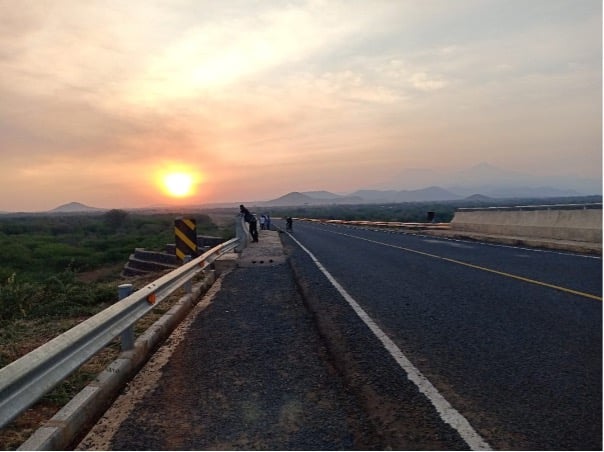
I got to the tarmac near Taveta at exactly sunset from which my hotel was around 15 minutes away. And what an amazing highway it is! The road was pretty empty (the border is closed, and curfew in place with Corona). Youth are listening to music hanging out on the bridges along the road. A girl is learning how to ride and is carrying her boyfriend. Women are taking walks chatting. I later learned that people waited for this road for over ten years…
At Green Park Hotel I had an amazingly warm welcome. Clean rooms, friendly staff, safe parking, I’d go here again. I had called earlier to book (1500 for bed and breakfast)
Day 3 – Day trip Lake Chala
I spent half the day relaxing, chatting with hotel staff, seeing the town and catching up with an old friend. It was interesting to learn more about the local history, the realities of living near the TZ border (remember how this border was drawn) and the economic opportunities. I mean who knew that our tomatoes come from Taveta? I was also told that the Oloitoktok-Taveta route will be tarmacked by a Chinese contractor in a year or so. (“This is Worldbank money. Our government won’t touch it, so we’re optimistic that this time the road will actually be made.”)
I should also mention that Abdallah is an experienced bike mech (Shop called Hayeez opposite KCB) and I got a few nuts & bolts tightened and the chain oiled after the bumpy and dusty Day 1.
Lake Chala is a crater lake and getting to the rim is now the real off-road riding. The one you see on YouTube. Or you can park downstairs or half-way and walk up. It’s only 5 minutes walk. There’s absolutely nothing up there, no bar, no soul and no noise – it’s beautiful! Carry water and swim suit.
Knowing the route and terrain well from last night, it took me 30 minutes from town to reach there. I’d say spend 3-4 hours on the Chala trip, so you get an hour or two to actually sit and relax and soak it all in. Maybe walk around the crater top or walk down to swim (it’s steeeeep!! Only excellent swimmers please)
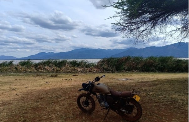
Day 4 – Day trip Lake Jipe
Let me start by saying that if at all you decide to go to Lake Jipe, you should enter Tsavo West and get to the KWS Bandas (500m from the park gate). I found no other place along the lake impressive (the lodge isn’t on the water and was out of my budget). The village itself is dusty, garbage heaps and you won’t get close to the lake or find a spot to truly relax (heat!).
You could leave Taveta early and get here by 11 to spend the day along the lake. You can’t swim (hippos and crocs) but you can hire a boat ride (1k per person), or simply hang out.
If you were to stay overnight, the KWS bandas are a great option (book early!) which are 3k for a unit (1 double and 1 single bed, so up to 3 peeps) or 500 for camping. Check KWS website for latest prices and booking phone number. What I learned with KWS is that the team on the ground can give you all details (weather, state of the road, is their tent still intact, does the meko have gas) so call and get the direct number to the KWS Tsavo West Jipe Gate team.
It’s all extremely simple, think campsite. Shared outdoors showers. The rooms are small and very basic but are 20m from the waterfront, with a clear view on the lake and of the Tanzanian hills. AMAZING!
Bring all food and charcoal. And mosquito repellant, towels, slippers and soap. There’s gas and sufurias in the kitchen, but I’d bring dish washing soap just to be sure. For a barbecue bring charcoal or buy from the nearby village. They have a tent they said they could put up but again – call in advance to confirm.
Now – the road from Taveta Town to the park gate isn’t great. The first 10km are doable (upto the castle which sadly seems closed to the public), then 10km rough road which was recently dug up and pretty messy. The last 10km is sand riding… Some patches are like a beach. The cruising and sliding is real fun!
From the park gate it’s 500m to the bandas. I was escorted by a ranger on a motorbike. Note that riding past the Bandas is not allowed as per KWS policy. I understood this policy intrinsically, when there was a single male elephant crossing the road ahead of us to get a sip from the lake (can you spot them on the pic?). It’s beautiful, you pass impalas and guinea fowls also.
There is an option to reach here through the Maktau gate but you’ll pay the park fees and also it’s not allowed for motorbikes. If you’re doing this entire route by car, it’s really recommended! You could exit through Maktau directly towards Taita Hills.
You really can’t get lost, but as I’m using the red mobile phone network, I had synced the entire county on Google offline maps, meaning I could always see where I am using GPS even when the signal was weak.
Day 4 – Taveta to Wundanyi
No reason not to leave early. PLENTY to see and experience today!
It was around 1 hr to Maktau, mostly riding through the national park. As the border is closed, I was mostly alone on the highway, with less than 5 cars on the 40km that you ride within Tsavo West. Sadly, fires had razed all flora near the road, so animals were very few. Thankfully it was uneventful with a few zebras and gazelles, and no elephants. There were strong side winds, so with my light bike I managed around 50 safely.
Next is Maktau where some 100 year-old history of the county comes to life. You can see the old railway line and station, and the Indian war cemetery… (I wondered where the African troops were buried and remembered) There were barracks worth 40,000 people here during World War 1. It’s now a dusty town with a police stop.
DO take a stop at Sarova (now managed by Pollmann’s). Have a coffee at the pool – you deserve it! They got two hotels but you can only ride to the first one (Taita Hills Resort). It’s around 25km after Maktau.
They have a small exhibition about the first world war sponsored by European budgets in commemoration of the centenary of World War I, covering lots of facts of the war: The British and the German thinking, the strategies, the different events and fights. It talks of the Indians that were shipped to build the railway from Voi to Taveta. The war ships. It talks about the 15 African porters who stood behind 1 frontline soldier carrying supplies through the Savannah. All in all, interesting to read as it was certainly not covered in my high school history classes. Remembering that the European capitals are 9,000 km and a month away drives home what an incredible mess colonialism was.
What they don’t even attempt to describe are the impacts of the same tribe/community fighting on both sides had on the local people and their communities and economy. We have a small mention that some of them “lost their will to live”. We don’t learn how this area and its people did between 1918 and 1963, how it came under Coast province and what that meant up to 2010 for life and people here. You’d have to find a well-informed and open-minded local to tell you that.
Back to the hotel: Location is excellent with great views from the rooftop viewpoints. I found the food average for such a fancy place. If your pocket allows, you can book a game drive, stay for a night and watch animals from the rooftop view points. They had just reopened after a 4 month Corona break and were still booting (or rather I hope so). Sadly, they were not ready for motorcyclists, as no car could be found to get me to the more beautiful second hotel (Salt Lick).
Next stop: Wundanyi and Taita Hills
The Taita Hills side of the county is a completely different experience: Green, lush and hilly. The ride from Mwatate up to Wundanyi was gorgeous. A smooth tarmac road is winding up the hills and takes you from 850m to 1400m asl. The tarmac ends in Wundanyi, but you can explore the various valleys from here on rough roads. I stayed at Taita Rocks Hotel, which was affordable, clean and had warm blankets for the cold night. They also got great views from the room’s balcony and decent food.
You could take a whole day or two to hike the different peaks (Wuria is 2228m high!) but I had around 4 hours and got to 2 peaks before it started raining. If you’re into off-road then go for it, otherwise just get a boda guy to take you around. They’re truly ninjas.
Someone had given me the number of a local guide who knew the best points to reach the peaks from. We had a great time, we used his bike, and he showed me his hometown. I really enjoyed taking videos instead of riding myself. The weather here changes every 20 minutes and it rained the entire evening and got pretty cold at night.
Final 1-2 days – Return to Nairobi via Mombasa Highway
The distance from Wundanyi to Nairobi is 370km. You can do it in one day or break it in two. Either way: Leave early!
I passed Voi at exactly 8am and reached Mtito Andei at 10am for breakfast. In my opinion the best place to stop is “Midway Refreshments” with organized parking, clean toilets and tasty food. Why was it not there when we used to take the bus to coast and they dropped us in these filthy dingy places at 2am?
So how is Voi to Mtito Andei?
It went surprisingly well. I think the stars just aligned for me: The highway was empty, the truck drivers were in a great mood. I did well with my average speed of 70. Some trucks overtook me. Others I overtook. When the road was messy, I stayed behind a slow moving truck to be safe from oncoming traffic.
It is very spectacular and you feel like stopping for pics all the time. While you can’t stop at every single beautiful Baobab tree, I did where I felt it was safe to do so…
I found riding past the maximum security prison at Manyani quite the experience, and imagined the meeting where it was decided to put it in the middle of 20,000 km² savanna full of predators.
A fellow rider had given me some tips for the highway, so I don’t want to keep them to myself: The 100km surface is almost entirely rough and quite bumpy. Some sections are smooth but they do not stretch far enough. Most of this section doesn’t have any safe run off areas as the edges of the rather narrow highway are not paved. You’re likely to encounter a good number of wild animals including elephants, gazelles, giraffes and zebras. You will need to be most vigilant in this section. There’s a 60km stretch which is nothing but a national park with no human amenities like houses, Petrol stations, shops etc. In other words, don’t screw up between Mtito Andei and Voi. You don’t want to be stranded here. Good thing is most trucks and buses will let you have your right of way due to lack of safe runoff areas. Keep your headlights on, own your lane and be willing to slow down when the crazy incoming drivers disregard your presence and overtake at your peril.
From Mtito Andei onwards it’s just a matter of staying concentrated. There’s good run-off space and it’s still quite scenic up to Makindu.
Once you reach Makindu, you’ve got two options: Continue up to Nairobi directly on the highway, or take the detour via Wote. You’ll add 35km to your journey (and probably 1.5 hours) if you take the detour. But it’s excellent tarmac, a break from the traffic and BEAUTIFUL riding and a chance to explore Makueni county.
From Makindu to Wote is approximately 75kms via Kathonzweni. A straight road with good tarmac and minimal traffic. Halfway through Wote town, take a left turn for the road to Nairobi. That’s where the fun starts. It gets twistier and twistier, passing the famous Makongo Viewpoint. This curvy 50k stretch with great views was the highlight of my trip in terms of joyful riding. I avoided Machakos town, but took the left turn at Konza which got me back to Mombasa road. A fast, virtually empty road save for occasional grazing cows and no speed bumps.
If you want to break this up into two days, you could ride up to Wote and get accommodation there. From Wote to Nairobi is still 130km and with the Athi River construction and traffic, you need to be fresh. I found Wote a nice town with friendly people. (I had lunch at a place called Becky’s Garden which yes, is a garden restaurant. They also got rooms for 1k). While I had a hotel along Mombasa highway, I would not do it again as I found these motels not pretty or serene or affordable. Sleeping in Emali for example is such a buzzkill from the beauty of this trip.
The total was 1,100 km on the road across 5 counties. I used fuel worth 2386 KES which speaks to smaller engines being affordable travel mates.
Our Top Experiences


CONTACT
enquiries@nomad.africa
Tel: +254 708 238 738
Purple Nomad Ltd
PO Box 69671 - 00400
Mwanzi Avenue, Nairobi, Kenya